Category Archives: wilderness additions

Granite Chief Wilderness additions

I have posted five proposed additions to the Granite Chief Wilderness:

These additions would add about 19,508 acres to the existing 28,374 acre designated wilderness, for a total of about 47,882. By Sierra wilderness standards, this is still pretty small. Desolation Wilderness is 63,960 acres, and many Sierra wildernesses are much larger.

The additions proposed are not refined. Though I have been in each of these areas, I have not spent time figuring out exactly where boundaries should be, nor identifying exactly what human disturbances have occurred. Some of these areas are pristine wilderness, and already in public ownership, and should have been added to the original wilderness, but were not. Other areas have been helicopter logged. And other areas were roaded and logged. The damage from logging is not really due to cutting trees, but to the roads built to haul the trees out to mills. These logging roads are almost always the main source of soil and debris washing into the watershed from rain and snowmelt. The American River Conservancy bought a number of parcels of former logging lands, some of which was added to the National Forests, and some remains with the organization but protected from many uses. I don’t think any of these areas will ever be logged again. The terrain is challenging, the distance to mills in long and much further than it was, since so many mills have closed. Just as with ‘people who live in glass houses shouldn’t throw stones’, people who live in homes made of wood should not oppose all logging. However, I think these logging operations were a one-time thing, when mills were closer and logging operations less expensive. Time to add it to the wilderness!

You might assume that as a wilderness user and enthusiast, my main reason for wanting a large wilderness is for recreation. But except for protecting a few sections of the Pacific Crest Trail not currently protected, my concern is not for additional recreation. Instead, it is for these reasons:

Watershed Protection: The additions would round out the Five Lakes Creek watershed, placing almost all of it in protection. Significant portions of the Rubicon River watershed would be protected, though the Rubicon 4WD Trail separates this area from the headwaters in the Desolation Wilderness. For areas that were roaded for logging, it is possible the roads need to be ‘put to bed’ to reduce present and future erosion. This work might take a number of years, and would delay formal designation as wilderness, but the goal should be eventual inclusion. As our climate warms and dries, but with much more erratic precipitation, we must protect as many watersheds as possible to maintain water quality, for nature and for us.

Larger Areas in Which Natural Fire Can Be Allowed: The Forest Service has sadly maintained a policy for putting out fires in the wilderness, no matter the location or time of year. All over the wilderness there are locations of a single tree or a few trees which were put out by the Forest Service rather than being allowed to burn. As a result, there is a huge accumulation of forest debris and an completely unnatural density of trees. Natural fire must again be allowed, to reduce the fuel load and return the forest to a more natural state. The larger the protected area, and therefore the greater distance between natural fire and human infrastructure, the wider the window of natural fires that can be allowed to burn. Human-caused fires of course are unnatural and should be suppressed. Prescribed fire, valuable in other places, it not appropriate for wilderness.

Places Where Nature is Left Alone: Humans have had an immense impact on the natural world. Some of it is reasonable, as our part of life on earth, but much is unnecessary, damaging to natural processes and resources when it did not need to be. As our footprint becomes more unsustainable, we need areas that are left alone, where nature proceeds in its own way. Of course human-caused climate change reaches everywhere, even into wilderness, but at least in wilderness natural resilience can mitigate and slow the change.

These are the reasons that I want Granite Chief Wilderness to be expanded. I’ve turned on these areas on my GaiaGPS map so that you can see them individually or as a whole. The folder is GCW_expansion.
Granite Chief Wilderness additions: Rubicon

This is the fifth of a series of posts recommending additions to the Granite Chief Wilderness. The first was Granite Chief Wilderness additions: Barker Creek, the second was Granite Chief Wilderness additions: Blackwood & Ward, the third was Granite Chief Wilderness additions: north area, and the fourth was Granite Chief Wilderness additions: Steamboat. See the first for background information on the wilderness and the idea of additions. In the near future I will do a summary post on all the additions.

Rubicon

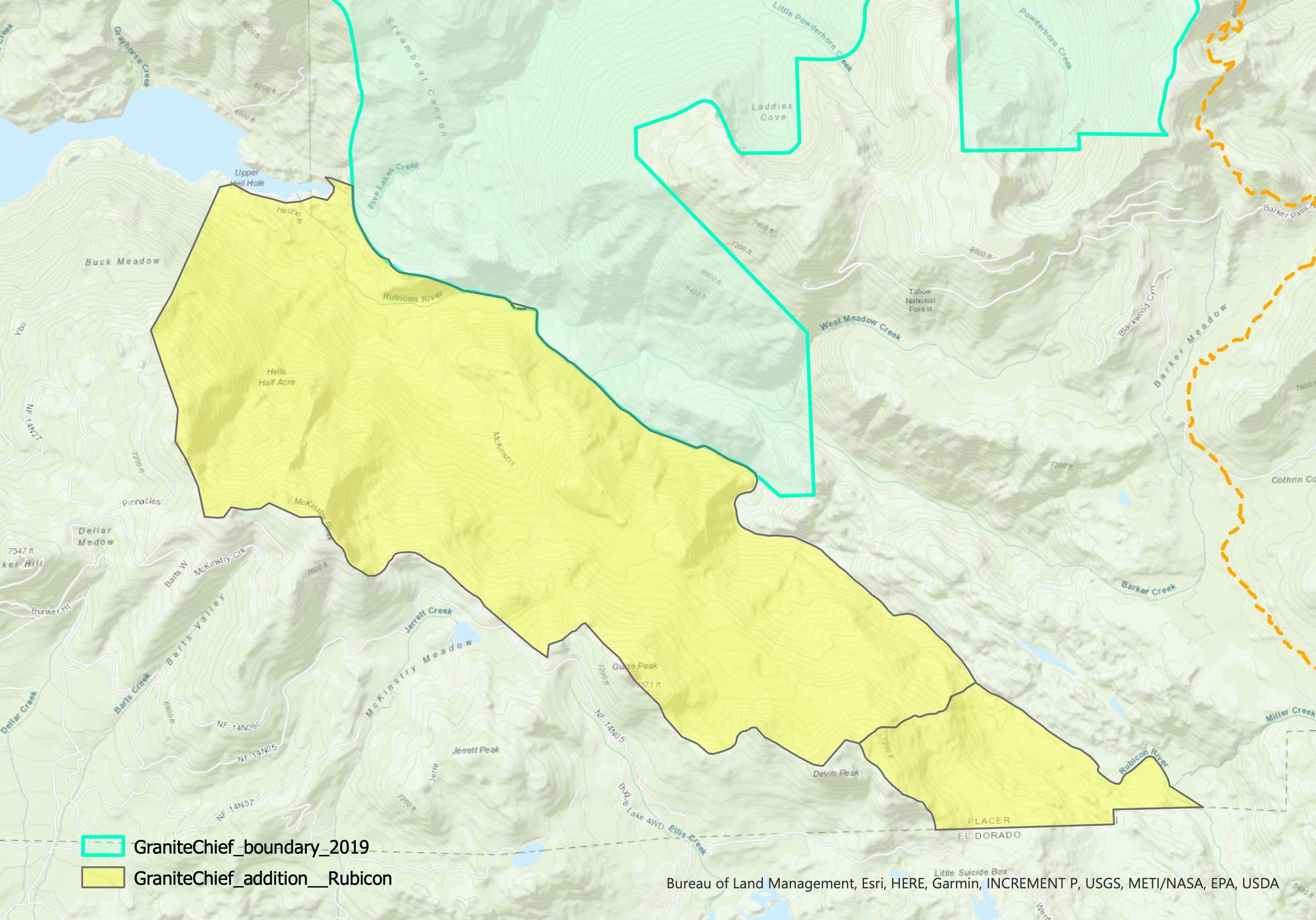
This area contains mostly pristine areas south of the Rubicon River that were left out of the original wilderness. It is about 5,257 acres, the largest of the proposed additions.

The area includes the north facing slope from McKinstry Peak and Guide Peak down to the Rubicon River, where it connects with the existing wilderness and the Barker Creek area of my first post. Some of the river flats along the Rubicon River were helicopter logged, but were not roaded. The road shown on some maps around the head of Hell Hole Reservoir does not exist, has never existed. Though there are a number of old abandoned and use trails in the area, particularly just east of the reservoir, the only maintained trail, Hell Hole 14E02, ends at the Upper Hell Hole Campground, just outside this addition. I have not been on the McKinstry Trail in many years, and do not know if it is even passable through the brush fields, but it would be included in the addition. Upstream, the addition ends short of the Rubicon Jeep Trail. It is all within Tahoe National Forest and does not extend into El Dorado National Forest.

Land ownership is mostly Tahoe National Forest, with some Placer County Water Agency (PCWA), which is the agency that owns and administers Hell Hole Reservoir and associated plumbing.

The map below shows the adjacent designated wilderness and the proposed addition. (pdf) The line separating the addition into two parts is an artifact of USGS watershed boundaries, which made the area much easier to map. Note that I have not added these proposed additions to my GaiaGPS public maps. After all five posts have been made, along with a summary post, I will add them.

Granite Chief Wilderness proposed addition – Rubicon

Granite Chief Wilderness additions: Steamboat

This is the fourth of a series of posts recommending additions to the Granite Chief Wilderness. The first was Granite Chief Wilderness additions: Barker Creek, the second was Granite Chief Wilderness additions: Blackwood & Ward, the third was Granite Chief Wilderness additions: north area. See the first for background information on the wilderness and the idea of additions.

Steamboat

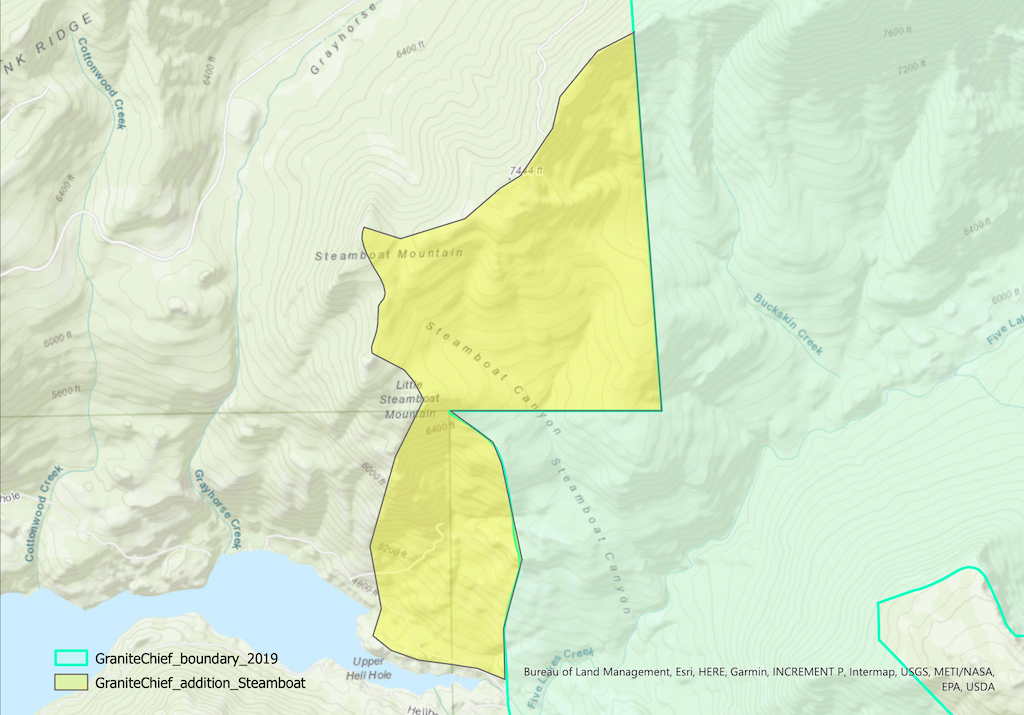
This area contains some pristine areas that were left out of the original wilderness, but also areas in the Five Lakes Creek watershed that were logged and roaded at one time. It is 1,311 acres.

The area includes upper Steamboat Creek, and upper Buckskin Creek. Though it has been several years since I walked this complex of logging roads, at the time they were all seldom used and rapidly deteriorating. It is probable that stabilization work should be done before inclusion in the wilderness. The north and west boundaries would be the watershed boundary of Five Lakes Creek. This addition, along with the Barker addition, would protect the entire watershed of Five Lakes Creek, critically important to maintaining water quality for the entire watershed. None of these lands should ever be logged again.

It includes the lower part of lower Hell Hole Trail, and the poorly defined route west along the north shore of Hell Hole Reservoir, and east along the north side of Five Lakes Creek. Note that maps do not show the correct location of these trails, and the road along the north and east sides of the reservoir was someone’s imagination – it was never there. The Buckskin Trail, shown on some maps, has not been maintained in over 40 years, and is very hard to follow even for experienced backcountry people. It should not be shown on current maps.

Land ownership is mostly Tahoe National Forest, with some Placer County Water Agency (PCWA), which is the agency that owns and administers Hell Hole Reservoir and associated plumbing.

The map below shows the adjacent designated wilderness and the proposed addition. (pdf) Note that I have not added these proposed additions to my GaiaGPS public maps. After all five posts have been made, along with a summary post, I will add them.

map of Granite Chief Wilderness proposed addition - Steamboat
Granite Chief Wilderness proposed addition – Steamboat

Granite Chief Wilderness additions: north area

This is the third of a series of posts recommending additions to the Granite Chief Wilderness. The first was Granite Chief Wilderness additions: Barker Creek, the second was Granite Chief Wilderness additions: Blackwood & Ward. See the first for background information on the wilderness and the idea of additions.

North Areas (Granite Chief Creek, north area, and Talbot Creek)

I have mapped these three areas separately, because they are not contiguous, but together they round out the north and northwest boundaries of the wilderness, protecting both pristine wilderness lands and areas that were once logged but are recovering. The three areas total 3,405 acres.

Granite Chief Creek: This is the upper Granite Chief Creek watershed. The creek is tributary to the North Fork American River. The north boundary is section lines, the south boundary is the current wilderness boundary, which is also the watershed boundary along Lyon Ridge. It is entirely Tahoe National Forest. This area is pristine wilderness, without logging or roads. It includes a little less than two miles of the Pacific Crest Trail, which is now outside the wilderness. It is 1,419 acres.

North area: This is uppermost part of the Talbot Creek watershed, which is tributary to Middle Fork American River. The north boundary is the watershed boundary, and the south boundary is the current wilderness boundary. It is within Tahoe National Forest and American River Conservancy lands. It was in part lightly logged and had logging roads, but those traces are fading, and there are no permanent roads. It is 398 acres, but the significance is greater since it would round out the upper watershed protection and protection of the Tevis Cup Trail, which were missed in the 2015 wilderness additions.

Talbot: This is another segment of the Talbot Creek watershed. The north and west boundaries are the watershed boundary of Talbot Creek, which is also the Tevis Cup Trail on Red Star Ridge. The south boundary is section lines. The east boundary is FR 51 and the Talbot Trail. It is within Tahoe National Forest and American River Conservancy lands, with a small inholding of private property, which could be excluded or acquired. Some of this area was logged and had logging roads, though there are no permanent roads. It is 1,687 acres.

My original vision was a significant northward expansion of the wilderness into wilderness-quality lands along the Pacific crest, including the Pacific Crest Trail as far as Anderson Peak, however, it turns out that Chickering American River Reserve, which I had assumed was state lands administered by University of California, is actually private lands with a conservation easement, therefore not available for designation as wilderness. I did not want to propose additions that are not contiguous to the existing wilderness.

A map is below, showing the adjacent designated wilderness and the proposed additions. It includes a section of the Pacific Crest Trail, shown on the map in orange dashed. (pdf)

Granite Chief Wilderness additions: Blackwood & Ward

This is the second of a series of posts recommending additions to the Granite Chief Wilderness. The first was Granite Chief Wilderness additions: Barker Creek.

Granite Chief Wilderness was established in 1984 with the California Wilderness Act, at about 24,000 acres (97 km2). About 10,000 acres were purchased by American River Conservancy under the Granite Chief Wilderness Campaign, some of which were added to the wilderness after restoration, mostly putting an old and barely passable road to bed (see new wilderness boundary), bringing the wilderness acreage to 28,374 (114 km2).

But there are extensive areas contiguous with the existing wilderness that are of wilderness character that I believe should be added to the wilderness. Some sections of the Pacific Crest Trail are not in the wilderness, when they could easily be with slight boundary adjustments. Some of the additions are pristine wilderness, and some are areas that were logged but are healing and could be added now or in the future.

I believe in wilderness, not just for the recreational value, but as areas we set aside for nature to flourish and heal, where we interfere little if any in natural processes. This has become all the more important with climate change and all the related issues including insect die-off and red fir die-off. When we have the opportunity to expand existing wilderness areas, we should. As our use of non-wilderness lands intensifies, we need to balance that will additional wilderness. The Granite Chief is one of those areas.

So, I will post a series on my proposed additions. It is a lot of work to look closely at maps and on the ground to develop recommendations, and then map them accurately. I’m using ArcGIS Pro to do this, and investigations on the ground. The posts may stretch out over a couple of years, and I’m guessing there will be at least six. When the series is complete, I’ll create a single map showing all the additions together.

Caveats

Some of the areas I’m proposing have been logged, many of them just before or just after the wilderness was established. I don’t believe that it will be economically possible, and questionably, environmentally responsible to log these areas again. The distance from the forest to remaining mills is just too great. Barker Pass Road was originally meant to go across Five Lakes Creek watershed to Mosquito Road and to mills in Foresthill or Placerville, but that will never happen, and those mills are long gone.

That is not to say there could not be fuel reduction projects, and perhaps some of these areas should be treated before inclusion in wilderness. Because of the misguided Forest Service policy of immediate suppression of lightning caused fire, even when far remote from human development, there are overstocked forests and years of debris on the forest floor, a conflagration waiting to happen. In the lower elevation forests, this is a completely unnatural, dangerous, and human-created condition. In the red fir and hemlock forests at higher elevations, it is not clear to me what the natural fire regime was or should be.

There are also logging roads associated with that logging. Almost all of these have deteriorated to be 4WD, not accessible for most recreationists, and are used primarily by off-road type users. This, in my mind, is not a valid use of National Forest lands. As an example, old logging roads on the mesas above Five Lakes Creek valley were closed for a while by downed trees, allowing nature to recoup and the peace and silence to return (see Granite Chief 2025-09-13 mesas). The views from the edge of the mesas are incredible, but the vehicle use here is not of that purpose, it is just for using vehicles. Unfortunately 4WD users with heavy chain saws and long bars managed to cut the trees out and return the roar of engines and tearing up of road surfaces. I have no sympathy for this.

Blackwood Creek & Ward Creek addition

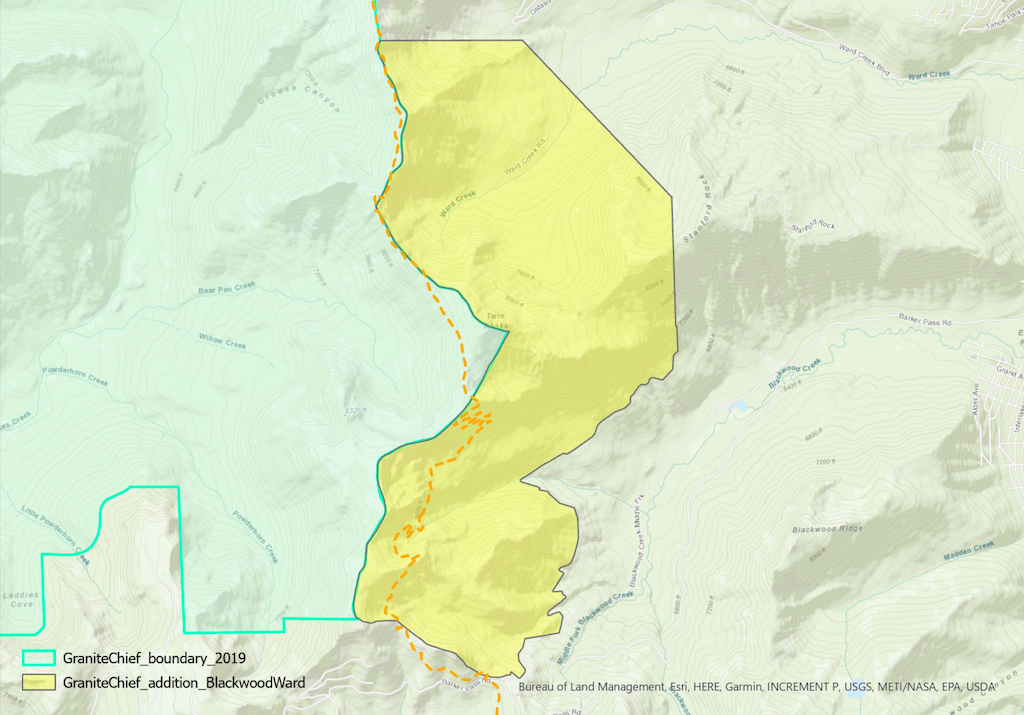
The first area I’m recommending I call the Blackwood Creek and Ward Creek addition. It is within the drainages of Blackwood Creek and Ward Creek, which are tributary to Lake Tahoe. It would not result in any road closures. It includes some logging and fuel reduction areas in both watersheds, but these are healing fairly well, with the access roads having been long closed. It also includes much pristine wilderness lands.

The area is about 3,825 acres. A map is below, showing the adjacent designated wilderness and the proposed addition. It includes a section of the Pacific Crest Trail, shown on the map in orange dashed. (pdf)

Granite Chief Wilderness additions: Barker Creek

Granite Chief Wilderness was established in 1984 with the California Wilderness Act, at about 24,000 acres (97 km2). About 10,000 acres were purchased by American River Conservancy under the Granite Chief Wilderness Campaign, some of which were added to the wilderness after restoration, mostly putting an old and barely passable road to bed (see new wilderness boundary), bringing the wilderness acreage to 28,374 (114 km2).

But there are extensive areas contiguous with the existing wilderness that are of wilderness character that I believe should be added to the wilderness. Some sections of the Pacific Crest Trail are not in the wilderness, when they could easily be with slight boundary adjustments. Some of the additions are pristine wilderness, and some are areas that were logged but are healing and could be added now or in the future.

I believe in wilderness, not just for the recreational value, but as areas we set aside for nature to flourish and heal, where we interfere little if any in natural processes. This has become all the more important with climate change and all the related issues including insect die-off and red fir die-off. When we have the opportunity to expand existing wilderness areas, we should. As our use of non-wilderness lands intensifies, we need to balance that will additional wilderness. The Granite Chief is one of those areas.

So, I will post a series on my proposed additions. It is a lot of work to look closely at maps and on the ground to develop recommendations, and then map them accurately. I’m using ArcGIS Pro to do this, and investigations on the ground. The posts may stretch out over a couple of years, and I’m guessing there will be at least six. When the series is complete, I’ll create a single map showing all the additions together.

Caveats

Some of the areas I’m proposing have been logged, many of them just before or just after the wilderness was established. I don’t believe that it will be economically possible, and questionably environmentally responsible to log these areas again. The distance from the forest to remaining mills is just too great. Barker Pass Road was originally meant to go across Five Lakes Creek watershed to Mosquito Road and to mills in Foresthill or Placerville, but that will never happen, and those mills are long gone.

That is not to say there could not be fuel reduction projects, and perhaps some of these areas should be treated before inclusion in wilderness. Because of the misguided Forest Service policy of immediate suppression of lightning caused fire, even when far remote from human development, there are overstocked forests and years of debris on the forest floor, a conflagration waiting to happen. In the lower elevation forests, this is a completely unnatural, dangerous, and human-created condition. In the red fir and hemlock forests at higher elevations, it is not clear to me what the natural fire regime was or should be.

There are also logging roads associated with that logging. Almost all of these have deteriorated to be 4WD, not accessible for most recreationists, and are used primarily by off-road type users. This, in my mind, is not a valid use of National Forest lands. As an example, old logging roads on the mesas above Five Lakes Creek valley were closed for a while by downed trees, allowing nature to recoup and the peace and silence to return (see Granite Chief 2025-09-13 mesas). The views from the edge of the mesas are incredible, but the vehicle use here is not of that purpose, it is just for using vehicles. Unfortunately 4WD users with heavy chain saws and long bars managed to cut the trees out and return the roar of engines and tearing up of road surfaces. I have no sympathy for this.

Barker Creek addition

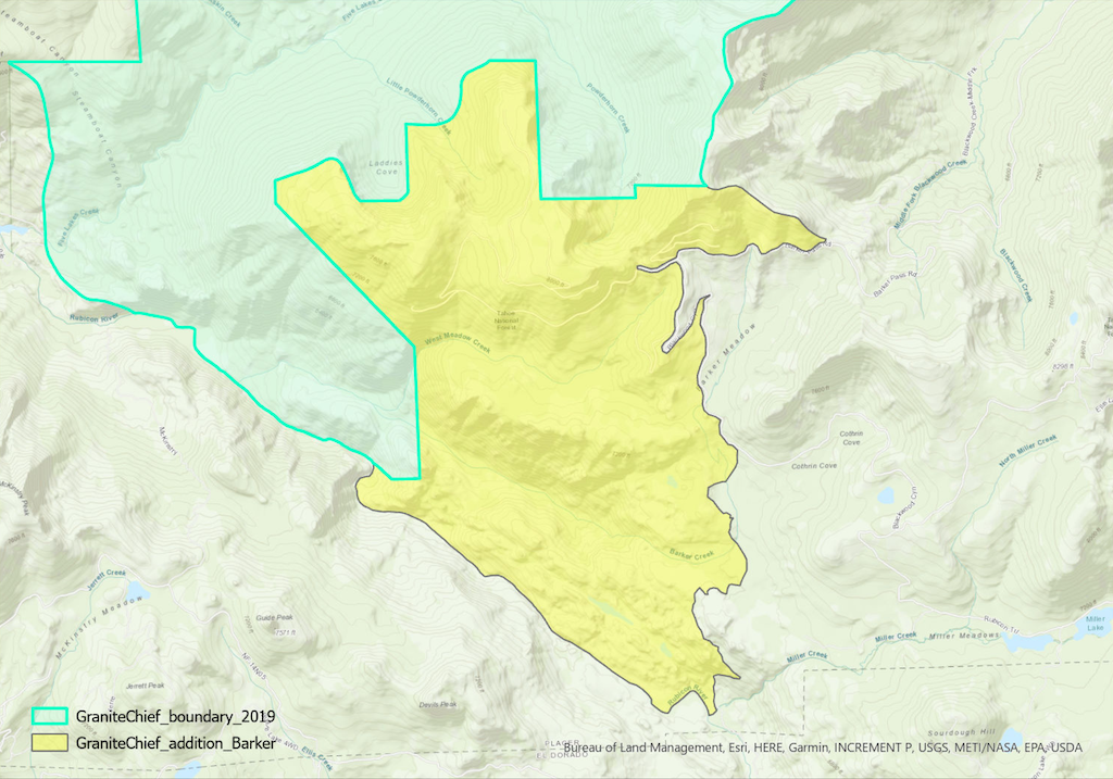
The first area I’m recommending I call the Barker Creek addition. It is within the Barker Creek drainage, which is a tributary to the Rubicon River. It would close Barker Pass Road at the Powderhorn Trailhead. It leaves open Barker Creek Road, which connects to the famous Rubicon 4WD trail, but it would close the rogue user-created roads off that road. It includes the logging area of West Meadow Creek, which was logged long ago, but is healing fairly well, with the logging road having been long closed.

The area is about 5,611 acres. A map is below, showing the adjacent designated wilderness and the proposed addition. It includes a small section of the Pacific Crest Trail, north of Barker Pass. The western boundary is the Rubicon River, which I’ve used for convenience of mapping, though there are wilderness quality lands west of the river as well. (pdf)