Granite Chief Wilderness was established in 1984 with the California Wilderness Act, at about 24,000 acres (97 km2). About 10,000 acres were purchased by American River Conservancy under the Granite Chief Wilderness Campaign, some of which were added to the wilderness after restoration, mostly putting an old and barely passable road to bed (see new wilderness boundary), bringing the wilderness acreage to 28,374 (114 km2).
But there are extensive areas contiguous with the existing wilderness that are of wilderness character that I believe should be added to the wilderness. Some sections of the Pacific Crest Trail are not in the wilderness, when they could easily be with slight boundary adjustments. Some of the additions are pristine wilderness, and some are areas that were logged but are healing and could be added now or in the future.
I believe in wilderness, not just for the recreational value, but as areas we set aside for nature to flourish and heal, where we interfere little if any in natural processes. This has become all the more important with climate change and all the related issues including insect die-off and red fir die-off. When we have the opportunity to expand existing wilderness areas, we should. As our use of non-wilderness lands intensifies, we need to balance that will additional wilderness. The Granite Chief is one of those areas.
So, I will post a series on my proposed additions. It is a lot of work to look closely at maps and on the ground to develop recommendations, and then map them accurately. I’m using ArcGIS Pro to do this, and investigations on the ground. The posts may stretch out over a couple of years, and I’m guessing there will be at least six. When the series is complete, I’ll create a single map showing all the additions together.
Caveats
Some of the areas I’m proposing have been logged, many of them just before or just after the wilderness was established. I don’t believe that it will be economically possible, and questionably environmentally responsible to log these areas again. The distance from the forest to remaining mills is just too great. Barker Pass Road was originally meant to go across Five Lakes Creek watershed to Mosquito Road and to mills in Foresthill or Placerville, but that will never happen, and those mills are long gone.
That is not to say there could not be fuel reduction projects, and perhaps some of these areas should be treated before inclusion in wilderness. Because of the misguided Forest Service policy of immediate suppression of lightning caused fire, even when far remote from human development, there are overstocked forests and years of debris on the forest floor, a conflagration waiting to happen. In the lower elevation forests, this is a completely unnatural, dangerous, and human-created condition. In the red fir and hemlock forests at higher elevations, it is not clear to me what the natural fire regime was or should be.
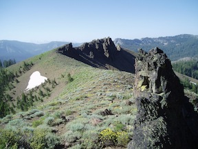
There are also logging roads associated with that logging. Almost all of these have deteriorated to be 4WD, not accessible for most recreationists, and are used primarily by off-road type users. This, in my mind, is not a valid use of National Forest lands. As an example, old logging roads on the mesas above Five Lakes Creek valley were closed for a while by downed trees, allowing nature to recoup and the peace and silence to return (see Granite Chief 2025-09-13 mesas). The views from the edge of the mesas are incredible, but the vehicle use here is not of that purpose, it is just for using vehicles. Unfortunately 4WD users with heavy chain saws and long bars managed to cut the trees out and return the roar of engines and tearing up of road surfaces. I have no sympathy for this.
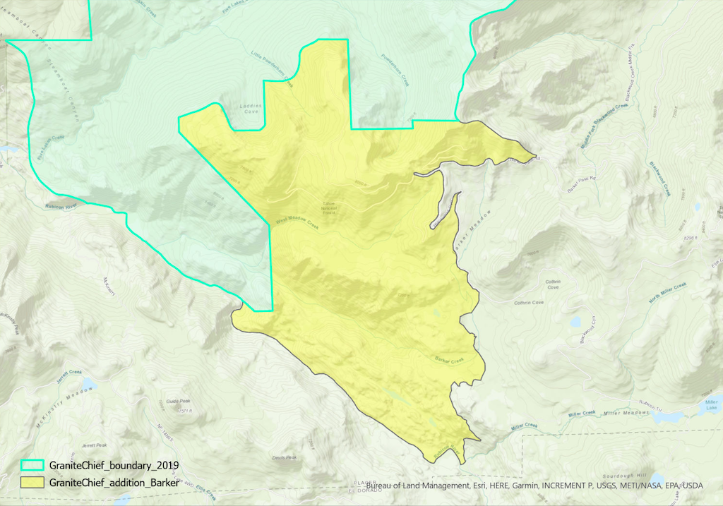
Barker Creek addition
The first area I’m recommending I call the Barker Creek addition. It is within the Barker Creek drainage, which is a tributary to the Rubicon River. It would close Barker Pass Road at the Powderhorn Trailhead. It leaves open Barker Creek Road, which connects to the famous Rubicon 4WD trail, but it would close the rogue user-created roads off that road. It includes the logging area of West Meadow Creek, which was logged long ago, but is healing fairly well, with the logging road having been long closed.
The area is about 5,611 acres. A map is below, showing the adjacent designated wilderness and the proposed addition. It includes a small section of the Pacific Crest Trail, north of Barker Pass. The western boundary is the Rubicon River, which I’ve used for convenience of mapping, though there are wilderness quality lands west of the river as well. (pdf)