Category Archives: Trip Reports

Off-trail explorations 2009-07-16

Washington Lily

On a four day backpack from Barker Pass, I did quite a bit of exploring off trail and on old trails. The snow has really disappeared since I was last in the wilderness in June, with just patches on or close to the trail now. And of course there are a lot more flowers now, except on the ridgelines where the flowers were already great.

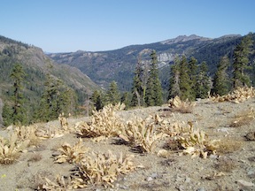
I explored Grouse Creek from the PCT down to the Five Lakes Trail. In the upper part I stayed as close to the creek as possible, but in the lower canyon it becomes too difficult to do so, and the bear trail led me out onto the ridge to the northwest, with great views back up Grouse Creek and up and down Five Lakes Creek. Washington lilies were poking up through the manzanita thickets on the ridge, and down along the ridge a number of dry rocky plants were blooming.

Continue reading

PCT survey backpack

snow on the trail at the wilderness boundary

On two short backpack trips from June 11 to 16, I surveyed the PCT from Barker Pass to Tinkers Knob. About half the trail was snow covered at the time, so I can’t say too much about tread conditions, but I did record the downed trees, of which there are a moderate number, some from last year (or several years ago in one case), and some from this year. Since over a month has passed since these trips, I won’t post the details about snow and trail conditions because they have changed.

There is a sign at the junction of the PCT and what I call the Western States Trail that says Tevis Trail and points at an angle for the trail departing to the west. I don’t remember seeing this sign before, thought it is well weathered, so perhaps it was on the ground and only recently placed back on a post. I still think this trail should be called Western States Trail since it seems to be the most common route of that trail over the years. The course for both the horse and running races has changed many times over the years.

Since the road to Barker Pass was still closed by snow, I walked up the 4WD road and back down the paved road. Once was enough, for both.

2009-06-11 to 2009-06-16

photos on Flickr

Picayune Valley 2008-09

Dried Wooley Mules Ears at head of Picayune Valley

I finally got to Picayune Valley, which rounds out my effort to see all the trails of Granite Chief. I came in from Alpine Meadows trailhead, which is the fastest way into the wilderness, went through Whiskey Creek Camp, and camped at the saddle above Picayune Valley.

Late in the day as it was getting dark, the shadows beneath the red firs were deep but the meadows still light.

Approaching dark
Trail through red firs
Darkness between the trunks
Thick and soft

Then out into the meadow
Wooley mules ears
Radiate the warm yellow sunlight
They’ve captured during the day

Continue reading

Powderhorn to Shanks Cove 2008-08-31

columnar lava “postpile” in Powderhorn Canyon

I had an enjoyable four day backpack from Powderhorn Trailhead, through Powderhorn Valley, to Shanks Cove and Grayhorse Valley to Whiskey Creek Camp and return. I was planning on getting into Picayune Valley, where I’ve not been yet, but lost a day off the trip and couldn’t fit it in. Next time! Continue reading

Granite Chief Trail 2008-08-24

Squaw Creek meadow and Granite Chief

For the first time, I hiked up the Granite Chief Trail which links Squaw Valley with the Pacific Crest Trail just north of the wilderness. I went on to the top of Granite Chief at 9006 feet, with a clear view in all directions.

The trail starts literally at the right side of the main fire station in Squaw Valley, which is just north of where the main road turns left towards The Village. There is a traditional Granite Chief Wilderness information sign, and a Granite Chief Trail sign, but no destination or mileage sign. The trail climbs past a ropes course and then steeply through private property below houses to a dirt road leading left to a large water tank, then becomes a trail again. The trail alternates steep rocky eroded sections with gentle smooth grades, all the way to the crest. I few seeps and creeklets are still flowing in the lower half of the trail. There are two major side trails, unsigned, that take off the trail in the lower half, not that noticeable going up but quite noticeable and confusing coming down. At the first split coming down, the right fork connects to the Squaw Creek – Shirley Lake trail, so take the left to stay on the main trail. At the second split coming down, I didn’t follow out the left fork, but the right is the main trail. When coming down past the water tank, the trail is not marked but leaves the road to the right not far down.

Continue reading

Hell Hole & Bear Pen 2008-08-08

Rubicon watershed

Rubicon watershed

I had an interesting trip through the Granite Chief and surrounding areas last week, starting at Barker Pass and coming back to it after some wild times through the Rubicon River drainage, Hell Hole Trail, and Bear Pen.

I started at Barker Pass, walked south along the PCT/TRT to Miller Creek, and then headed west on the Rubicon “trail” which is an OHV trail. I’d heard about this trail for years, but had avoided it, and certainly never driven it since I have only a passenger car. I actually enjoyed the people I talked to along the way. Hiking up out of the Rubicon River, the OHV trail gets worse and worse, but the traffic seems to stay low and the people friendly and responsible. From Buck Island Lake north, closer to “civilization,” however, the people get worse and worse. More trash, more blaring music, more frowns, more toilet paper everywhere, more transmission fluid on the ground, fewer Jeeps and more breakdowns. I was glad to leave the OHV trail and head north along a logging road. Of course on that road there where whining crotch rockets, zooming up and down, for entertainment value. It is interesting to see when things cross over from people who use their vehicles, of whatever sort, to access nature, and when they use them simply for entertainment and could care less about nature.

Continue reading