Monthly Archives: August 2024

Powderhorn trail work complete! 2024-08

This backpack trip was just for doing trail work on the Powderhorn Trail, to make up for two aborted or shortened trail work trips earlier this year. And I completed the trail! Yay!

There is a real pleasure to walking a well-maintained trail.

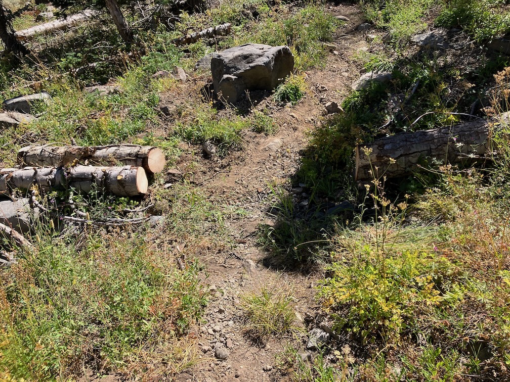
Of course trail work is never really complete. While doing trail work, things are growing, and dying, and falling. The upper section of the trail is noticeably needing brushing and removing conifer encroachment, developing in the time since I worked that section.

I was curious about my history with the trail, so looked back at earlier posts.

  • 2009: The trail was logged out by the Forest Service. This is the last time the FS worked on this trail, 15 years ago, so far as I know. All of the older, rotted and aged and often large down trees, were cut at this time. I don’t know if any other work was done at the time.
  • 2010-2017?: A horse group rode in every year to Big Spring Meadow for a long camp. On their way in, they cut enough of the trees to keep the trail open and useable. I don’t know whether their plans changed or they gave up on the trail and went elsewhere.
  • 2018: My first trail work, spot brushing and removing conifer sprouts (mostly red fir) that were closing in on the trail.
  • 2021: My first focus on Powderhorn, including marking the location of down trees. At that time I was still hoping that the Forest Service would log out the trail again, and so relayed to them the size, nature, and location of the trees. Though they thanked me for this year, they ignored later submissions, so I stopped sending them.
  • 2022: Continuing work on the trail, mostly the upper third.
  • 2023: Continuing work on the trail, mostly the lower third.
  • 2024: Continuing work on the trail, mostly the middle third.

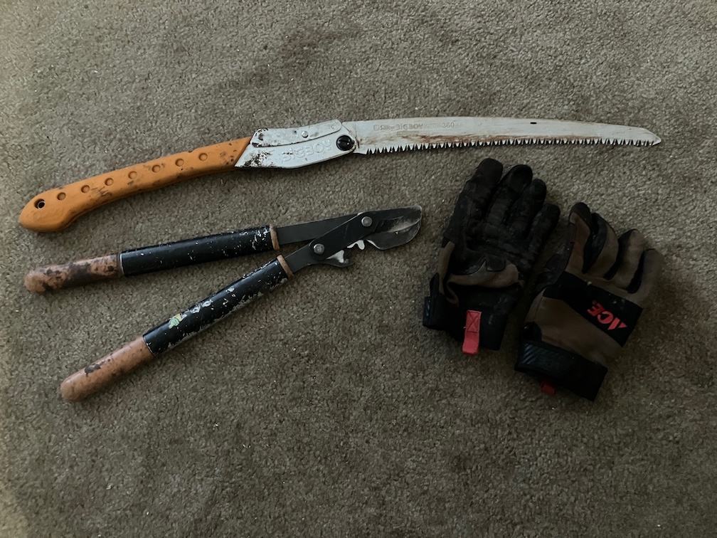
I recently bought a new trail tool, a Silky Big Boy 2000 15-inch folding saw, to replace my Fiskars 10-inch folding saw. What a difference! The length has allowed me to cut many smaller down trees that I had always had to ignore before. The saw easily cuts 9-inch logs, and at a stretch 12-inch logs, though 12 inches is slow going. Radius SQUARED really makes a difference. And being new, the saw is sharp and cuts well on the pull stroke (it is designed to cut on the pull and won’t work pushing). There were quite a number of new down trees this year over last year, but with cutting the smaller stuff, the overall number of down trees is now less than last year. For those wanting to know the details, my GaiaGPS folder ‘down-tree‘ shows all of them on the Powderhorn Trail.

photo of tools of the trade: new Silky Big Boy folding saw, Fiskars nippers, and gloves
tools of the trade: new Silky Big Boy folding saw, Fiskars nippers, and gloves

If you like the Powderhorn Trail, or have been thinking about going there, now is the time! By next year there will be new down trees. About half the red fir trees are dead, though it varies from nearly all to very few. Of course there are abundant sprouts crowding the trail. Some of these will die and become what I call spars (similar to snags, but I use snags for large standing dead trees) and lean into the trail, ready to snag your clothes or skin. A significant percentage of young red firs develop a lean, hanging into the trail. I call them leaners. The standing dead have prominent white mushroom bodies all over the trunks, so they are already rotting while standing, and will fall. It used to take a high wind year with saturated soils to being down trees, but they are now falling year-round.

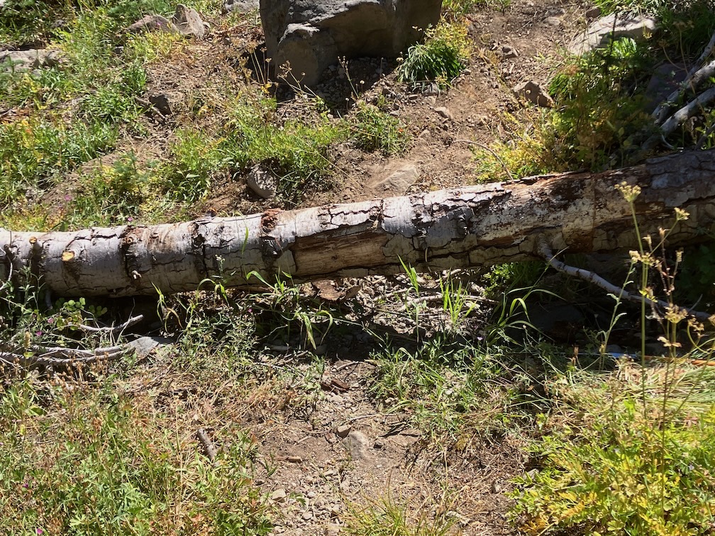
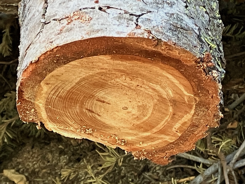
One of the down trees far too large for me to cut, I worked on the approach to the tree so that people could climb over or slide under. This red fir has the most dense wood I’ve ever experienced. A five-foot cut section of branch was so heavy I could hardly lift it. This must have been a very old and very slow growing tree. I’m unsure whether it died and fell, or was knocked down by another tree.

photo of dense red fir rings
dense red fir rings

The trail has at least two down trees that cannot be passed by horses, so it must be considered closed and dangerous to equestrians. One is the slide-under tree, where backpackers can slide under the down tree. I had roughed out a bypass two years ago, but a new tree fell directly on the bypass, closing it. Another down tree would be a challenge to all but very trail-wise horses, and there is no bypass.

Sometime earlier this summer, someone rode a dirt bike into the wilderness and about a mile down the trail before giving up at a large down tree with no bypass. That person did quite a bit of trail damage and left ruts that will erode next spring. The power of internal combustion engines causes brain damage and immorality.

Five Lakes Creek is flowing but noticeable low. Same for Powderhorn Creek. The creeklet that crosses the trail is barely flowing and may be dry soon.

I have often done a trail condition survey trip early in the summer, but did not do so this year, so know nothing about trail conditions except the PCT, good condition, Whiskey Creek Trail, good condition, Five Lakes Trail, good condition, and Five Lakes Creek Trail, horrible condition. I may get to the other trails on my next trip.

Photos on Flickr:

Granite Chief 2024-08 smoked out!

This was a ‘didn’t go as planned’ trip. My plan was to do a lot of trail work on the Powderhorn Trail.

Train to Truckee, bus to Tahoe City and then Barker Pass Rd. I had hoped to hitch-hike to Barker Pass, but it was a weekday in the afternoon, and all the vehicles were going out, not up, so after a short hitch to the campground, I walked up the jeep road to the pass and then to Powderhorn trailhead. On my way up on the train, people were commenting on the smoke plume to the south, which turned out to be the Crozier fire north of Placerville. When I got to Powderhorn saddle, the plume was quite visible and spectacular, overhead. I started down into the canyon, but in short order the smoke descended into the canyon, reducing visibility to less than a quarter of a mile. I went back up to the saddle and camped there, where the air quality was a little better.

Crozier fire smoke plume

In the morning, smoke was filling Powderhorn, so I waited, and walked west on the old logging road to the creek, refilled water, and then back along the Barker Pass Rd to the saddle. The air cleared mid-morning, so I headed down and started my trail work. I have a new folding saw, which I’ll say more about next post, that allowed me to cut some down trees that I’ve always had to bypass, plus a little spot brushing. And then the smoke descended again, worse than before. So I headed out, and went to Barker Pass where the air was better, camped, and waited to see what would happen. Both the Rubicon drainage to the west and the Tahoe basin to the east were socked in with smoke in the morning. I realized that the only thing to do was head south on the PCT, away from the smoke plume. I was surprised by the number of PCT thru-hikers I saw, seems late in the season for them to be here.

By Richardson Lake, the air was good, and continued to get better on the PCT south. Looking back north, I could see that the smoke had descended into the valleys again, so if I’d tried again, I would have gotten smoked out again. There are a few patches of snow in the Crystal Range, but much less than two weeks ago. I spent time at my favorite juniper along the PCT, and then headed down into the General Creek drainage.

The connecting trail from PCT down to Genevieve Trail (which used to be called the General Creek Trail) is not really a trail. It was never constructed, has a lot of down trees, and is very hard to follow in places. This time of the season General Creek is just large pools with no flow, so is easy to cross, but I’ve had problems with that earlier in the season. I camped near the trail junction. This is a seldom used area. In the morning I headed over to Genevieve Lake, on a trail in decent shape with some down trees but easy to follow.

The Meeks Creek Trail (also called Tahoe Yosemite Trail on many maps, but it is a relict name) is a different world, only wilderness in name. Suddenly a whole lot of people, and more and more heading down Meeks Creek and out to the trailhead near Meeks Bay Resort. After iced tea, to Sugar Pine Point SP for a shower, then on to Tahoe City and Truckee, and the Amtrak bus home.

Photos on Flickr:

Powderhorn trail work 2024-07

I started this trip at Granite Chief Trail in Olympic Valley, as it is the most convenient trailhead. The evening before I attended the Palisades Tahoe Bluesday concert in the village. A lot of people there, many from the Reno area, and the Reno blues group is one of the event sponsors. Camped out at a favorite spot part way up and off of the trail after the concert, and then headed up the trail early morning. My break was at a juniper tree about half way up, where I have often stopped, but someone has made a nice bench out of a dead juniper trunk, just below the tree. There have been helicopters up all morning, but over the ridge south, in the Alpine Meadows / Bear Creek valley. Probably a lightning strike tree.

Thunderstorms were building over the Mt Rose area northeast of Tahoe, but I don’t know if rain came of it. Someone at the concert was mentioning heavy rain that afternoon, but I didn’t catch where. As with last trip, there is zero precipitation in the forecast, but the reality is different. But I had no rain on this trip, and one full day of completely clear skies.

photo of 
Angelica lineariloba, Apiaceae

I headed south on the PCT and then to Whiskey Creek Camp. There are a lot more PCT thru hikers than I would expect at the end of July. A few of them may make Canada. Then down Five Lakes Creek Trail, which raises my frustration level, climbing over down trees for long stretches. I took the main trail, not through Big Spring Meadow, and it appears to be unused until it rejoins the meadow trail. I lost it several times before and after the junction with Shanks Cove Trail. I walked a short distance on Shanks Cove, at it also appears unused. The few people who use Five Lakes Creek Trail go through Big Spring Meadow, which is understandable, it is a beautiful place. And the spring, though hard to access, is wonderful water. I camped at my common site beside Five Lakes Creek, off the trail near Diamond Crossing.

I did two and a half days of work on Powderhorn Trail. Though I had done the lower one-third last year, there were new down trees and winter debris, so I re-worked that section. I had laboriously cleared a bypass of the slide-under tree, safe for at least backcountry-wise horses. But a tree came down on the bypass, so the Powderhorn is again not accessible for equestrians. I then tackled the part I’ve not maintained in many years, the middle third. I made good though slow progress, completing up through the postpile meadow to the creeklet. This is about another 1/6, leaving 1/6 yet to do. And that 1/6 is largely a mess, about 1 km of down trees and winter debris, including one tree fallen directly on the trail.

I saw eight backpackers and two day hikers on the Powderhorn, which is a little surprising for a difficult trail that seems to be not much used. So maybe my work is worthwhile. It is certainly a pleasant experience on some parts of the trail, and if I can make is so, it is worthwhile.

photo of Ageratina occidentalis, Asteraceae
Ageratina occidentalis, Asteraceae

I explored the Hell Hole Trail from the Diamond Crossing junction to Five Lakes Creek. It is hard to follow through the seasonal growth and dry grass. There are duck markers but they aren’t all inter-visible. The most recent trail alignment is very hard to follow as it approaches Five Lakes Creek, though the alder thickets. Someone has partly ducked an alternative route that stays north of the dry drainage and comes out on the gravel bar just upstream of the crossing. It is also not well marked, but may be a better alignment. The ducks/cairins that I had set up two years ago are all gone, washed away or fallen over, but the crossing is upstream of the log jam across the creek. It may be a little hard to find the trail on the west side of the creek, but once found, it should be pretty easy to follow. I’ve spent a lot of time finding and clearing this trail, all the way to the bottom near Hell Hole Reservoir. Of course, as with every trail, it has a lot of down trees.

After a half day of trail work, I headed out Powderhorn Trail, FR 3 to Barker Pass, north to the PCT-TRT trail junction, and then down the TRT into Ward Creek, and camped at a small site beside a creeklet. Though I hadn’t really needed my inner tent for mosquitos on this trip, I did here, ample mosquitos. All day there had been a strange overcast, which turned out to be smoke aloft from the Park Fire. Nothing at ground level, where the smoke is going north and east, but smoke aloft was coming south.

Next day I walk out to the road and down Ward Creek to Sunnyside, and caught the bus into Tahoe City. Went to the Commons Beach concert, and camped in the forest nearby, then morning TART bus to Truckee and the Amtrak bus home.

An update on my inflatable sleeping pad. After patching some small leaks, it was still deflating during the night at an accelerated rate. So after seven years of good use, it is retired. I bought a Nemo Tensor inflatable sleeping pad as a replacement. Slightly more weight and slightly bigger, but in the same range.

Photos on Flickr: